The Metropolitan City of Milan is one of the most densely populated urban areas both on a national and European level. As regards climate change, it undoubtedly represents an area subject to the critical issues, typical of many metropolitan areas, in particular the Mediterranean ones.
Some of the most important issues affecting Milan Metropolitan area are: i) hydrogeological risks related to the disposal of rainwater linked to the intensification of stormwater phenomena; ii) excessive soil consumption; iii) pollution and scarcity of water resource; iv) heat waves; v) non-renewable energy over consumption.
These are real environmental emergencies for the metropolitan area that require specific and innovative planning approaches. The Metropolitan City of Milan has therefore defined within its general planning tool, the Metropolitan Territorial Plan, an action strategy for its entire territory, improving the integration of adaptation policies within territorial planning and creating the necessary framework for the concrete implementation of initiatives that contribute to increasing the resilience and adaptabilily of the territory to the most appropriate scale.
To reduce the impact of climate change and to contrast climate impacts in the medium and long run it is important to include mitigation and adaptation measures in an integrated way within the planning and territorial governance tools. The Metropolitan Territorial Plan has chosen this approach because of its strategic value and because it diversifies the management levels, involves multiple and diverse stakeholders, and differentiates the interventions areas. The Metropolitan Territorial Plan has included the strengthening of territorial resilience to climate change in the general principles to adopt the plan, setting out climate mitigation and adaption rules in a section dedicated to environmental emergencies, in line with the Metropolitan City Strategic Plan 2019-2021.
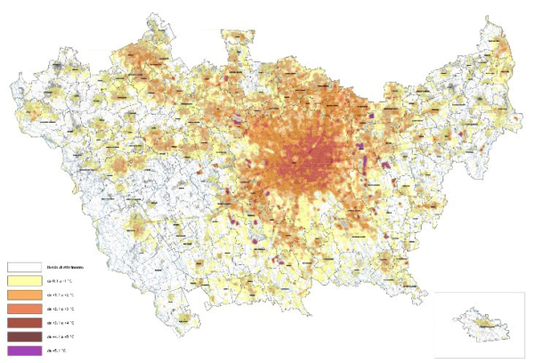 Starting from the analysis realized by the LIFE Metro Adapt project, the Metropolitan Territorial Plan has created a map that identifies territorial thermal anomalies. The most intense color in the map indicates a greater difference between the urban and rural temperatures. In the most critical situations (night values 3°C higher than the reference value) the Metropolitan Territorial Plan requires municipalities to develop a study to reduce the anomalies. The Plan provides municipalities with guidelines and instructions to include mitigation interventions in the urban planning tools and building regulations.
Find out more consulting the Metro Adapt Platform.